
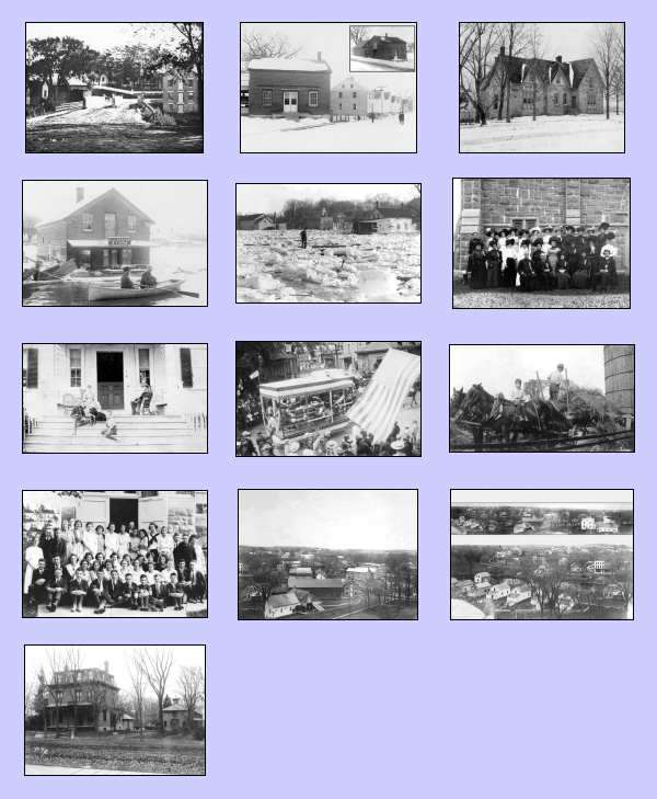
2007 Champlain Historic
Calendar
The
Founding of the
Village
and Town of
Part I
Towards the end of the Revolutionary War, the State of New York authorized the raising of two army regiments on bounties of unappropriated land. For his service, Pliny Moore received a large land grant from the State that became most of the current Town of Champlain. Towards the end of his enlistment, he surveyed this land and organized the settlement of the village and town by other soldiers who were paid with similar land bounties. In May of 1788, Pliny established the settlement of Champlain and became one of the first residents of the future village. Pliny’s letters give a first-hand account of the founding of the Village and Town of Champlain as well as the creation of Clinton County.
Pliny Moore was born in Sheffield, Massachusetts, on April 14, 1759, and was a descendent of some of the first English settlers of Massachusetts. His family later moved to Spencertown and Kinderhook, New York, where he spent most of his childhood. After the Revolutionary War started, Pliny enlisted into the army in April of 1776 at the age of 17. Pliny had several enlistments and served under various commanders in the Albany area and Mohawk Valley. By 1781, he was a Lieutenant and Adjutant. One of his jobs was to keep track of the soldiers’ enlistments and to record and disseminate orders from his commanders.
New York States Passes the Land Bounty Laws
On March 20, 1781, and March 23, 1782, New York State passed two laws to raise regiments for the defense of the state. The state pledged to give away bounties of unappropriated “wasteland” in the western and northern parts of the state as payment for a soldiers’ service. The amount of land a soldier was given depended on his rank. A non-commissioned officer and private would receive 100 acres, a captain would receive 300 acres and a colonel 500 acres. Sometimes the soldiers re-enlisted after their service ended to earn more land. For his service, each soldier was given a land certificate indicating how much land they were owed. Because Pliny was educated, good at keeping records and was well respected by his fellow soldiers, they appointed him to find and secure the lands that were due them. Twenty-two soldiers signed their first bond (agreement) with Pliny on March 21, 1782.
Pliny was often in communication with his father Noadiah concerning the securing of unappropriated lands. His father pressured him to find the best land within the state. In one letter, dated May 17, 1782, his father wrote “I Saw Major Hitchcok from Albany who Tells me that the Albany Gentlemen have Located a Large Quantity of Land at and Near fort thunters at Crown Pint Lake gorge Jeseps Paten &c you are Too Slow those Lands are Twice the Value or 3 times as you may git by Waiting Longer I advise you & Capt Write to go To Som Gentlemen in Albany and find by surveyor plans and Maps perhaps you may find a Wedge of Lands Some Where Between Two pattens where you may Git Something Good and near by Mr. Abraham Yates may be the man or Some other Consideration you have Waited Two Long all ready…”
A second letter written by Pliny’s father on June 25, 1782, shed more light on the passage of the law by New York State and the pressure of finding good land. Noadiah wrote, in part, “…hath Taken advice and finds the Indians Can Locate all of the Lands that are unapropriated and the Esqur Sons have bought up a number of Soldiers Rights and mean To Lay 5000 achers by way of Indians on these Disputed Lands.” This is also the first letter to mention James Dean (1748-1823) of Whitesboro, who was an acquaintance of the Moore’s. Dean was the government agent with the Oneida Indians in Western New York and soon became instrumental in the securing of the Champlain land grant for Pliny. Noadiah wrote,”Mr. Dean hath ben to Albany hath Don nothing Wants your Sertificate but is Disapointed about that Place he aimed at and hath found non as yet …Says you can Do as you pleas with all of your Locations Except your one Between you and him that he thinks he Can Lay out for beter advantage when he Returns.”
A
second
bond
was
signed
by
Pliny
and 20 more soldiers on July 3, 1782. This was about
three months after the second Land Bounty law was enacted
by the state. In the agreement, the soldiers
appointed Pliny to act as their agent to find and secure
unappropriated lands within the state. This contract
was to give Pliny one-fifth of the soldiers’ land and pay
him 10,000 Pounds.
:
:
On July 10, 1783, Pliny signed a third and final bond with 21 more soldiers. The agreement stated that Pliny was to receive one fifth of the lands of the other soldiers plus 10,000 Pounds of New York money. In all, Pliny had been appointed by 62 soldiers to secure land for them (one soldier was listed on both bonds so the total number of soldiers listed on all three documents was 63).
10th July 1783
Soldiers Bond and
Power to secure for Locating — £10,000
We whose hands and seals are hereunto Afix’d having Engaged in the Service on the Encouragement given in Two Acts of the Legislature of the State of New York passed the Twentieth of March Seventeen Hundred & Eighty One and Twenty third of March Seventeen Hundred and Eighty Two, for Raising Two Regiments for the defense of this State on Bounties of unappropriated Lands &c. Being sensible of the necessity of having a Seasonable Location made of the Lands to which we are entitled; do for that purpose
:
:
Pliny’s First Survey of Champlain - 1785
Pliny’s first survey of Champlain was in March of 1785. He left Kinderhook on March 1 with Daniel Clark and James Savage and traveled by foot up through Vermont on what would become Route 7. They crossed the lake at Colchester Point (probably where the sandbar is today) and traveled up through Grand Isle to Alburg before crossing back to New York. On March 10, near Rouses Point, James Savage fell through the ice and was rescued. Surprisingly, the men lodged at many settlers’ houses during the entire trip, even on Grand Isle and in Alburg.
When Pliny crossed the lake to Rouses Point, he found the province line survey marker that separated New York from Quebec. It had been placed there on August 15, 1771, by A. Binzell and John Collins when they did a survey for the British government. The marker would have been on the Fort Montgomery reservation.
By March 16, after almost two weeks of travel on foot, the three men reached Champlain and started doing a general survey of the land. Pliny marked the land with markers or ax cuts in the bark of the trees and created an outline survey with only a general description of the land.
:
:
March 1st, 1785 Set out from Kinderhook with Esqr Savage & Daniel Clark to make a Survey of a Location the West side of Lake Champlain West through New Concord New Canaan New Lebanon to Hancock Lodgd at Mr Elys Tavern.
: : : : : :
10th went to Grigs & Schuts on the Latitude Line 45 Degrees N. calld on Jno Savage Esqr Savage fell in the Ice. Lodged at said Suett & Grigs house.
15th set out to Survey Came to the Monument on the West Shore of the Lake about 3 Clock P.M. Province Line surveyd 15th Augt 1771 by A. Binzell & I. Collins. Run one Mile & Encampd
16th [Pliny begins the survey of Champlain] Kept forwards through a Large Cedar & Hemlock Swamp. 2 Miles & 40 Rods from the Lake the good Land begins, fine Rise & Brook 2 Miles 3 qr & 14 Rods is the heigth of the Beach Ridge from whence it decends gradually 66 Rods to the 3 Mile Monument ¾ a Beach Tree on the South [NE corner] Side of the Line markd 3. M. March 16th 1785 ¾ about 10 Feet direct west of it is a Maple projecting East & nearly:
:
The “Great Deed” of February 1787
By February 6, 1787, the lots in Champlain were ready to be balloted in what was called the “Great Deed”. Pliny divided the 119 lots into four divisions based on the quality of the land (as determined by his survey), with the First Division representing the prime land and the Fourth Division representing the waste land. Most of the soldiers were to receive 350 or 500 acres which was to be divided among the four types of divisions. Pliny was to receive 1,000 acres for his service alone.
Pliny Moore Settles Champlain — 1788
By May of 1788, Pliny was ready to make the initial settlement of Champlain. He left Kinderhook on May 12 and came up to Champlain with about 10 men, including Elnathan Rogers, Samuel Ashmun, William Beaumont, Joseph Rowe and Caleb Thomas. On May 23, they arrived and started to build a sawmill on the road to Perry’s Mills (a historic plaque was dedicated at this site in 1938). Pliny built a log cabin where the Elm Street Bridge and old bank building are today. In November, he went back to Kinderhook and stayed there for the first part of the winter. Pliny came back to Champlain in February of 1789 with his new wife and infant son Noadiah and lived there the rest of his life.
The Establishment of Early Champlain – Part II
In Part II of this series, the 2008 Calendar Historic Essay will focus on the growth of Champlain after its founding in 1788. In the first days after their arrival, Pliny and the settlers planted vegetable gardens for themselves and began construction of a dam, sawmill, and huts. By July of 1788, a “raising” was held for the sawmill. Pliny’s diary reveals the hardships and fatigue the settlers endured with the word “sick” often used to describe several of the worker’s conditions. Over time, more settlers arrived in Champlain and helped to establish a more stable settlement. With the creation of the new town and county, elections were soon held for county offices. Between 1800 and 1853, various churches were organized with the help of traveling missionaries. Life in the frontier wilderness was not easy as many of Pliny’s letters will reveal.
:
:
The Village of Champlain’s Name
So why is the Village of Champlain named “Champlain”? Obviously, it is named after Samuel de Champlain who explored the lake in 1609. A second look, however, reveals that the early Champlain settlement had a different name and for many years there was a lack of consensus as to the name of this settlement.
On Pliny’s second survey trip to Champlain in October of 1786, he called his new settlement “Moorsfield on River Chazy”. This naming convention was not unusual. Jacques Rouse has Rouses Point (really Rouse’s Point) named after him. Zephaniah Platt named his settlement Plattsburgh and Mooers is named in honor of General Benjamin Mooers of Plattsburgh (who never settled there).
:
:
the Clinton County Historical Association in Plattsburgh, New York or the author.